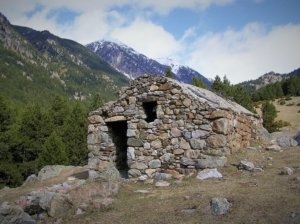
La Tosa d’Alp

La Tosa d’Alp

La Tosa or Tossa d’Alp is perhaps the most used mountain in the Cerdanya due to the fact that the Alp-2500 ski resort is located there, which includes the ski resorts of La Molina and Masella. It is very popular because a number of ski lifts, including a cable car, lead to the culminating plateau, where the “Niu de l’Àliga” refuge is located. However, if you leave the slopes a little, this human presence disappears and you enter into Cadí-Moixeró Natural Park. The overview from the summit, on the other hand, covers the whole of Cerdanya and a good part of Catalonia.


La Tosa d’Alp

Technical Data


Access: From Alp take the road that leads to the reception of the ski resort of Masella. Then continue to another road on the right until the Coma Oriola car park ends.

Start: Coma Oriola car park.

Difficulty: Easy

Maximum altitude: 2,537 m

Elevation gain: 615 m

Total duration: 2 hours (1.30 hour one way / 0.30 hour return)

Time of year: Spring, summer and autumn.

Notes: In the winter, the ascent is not recommended because you must go through the ski area and on the highest part you can find frozen snow, only accessible with an ice axe and crampons.

Route


From the car park at Coma Oriola (1,940 m) you have to go to the hole of the same name, following the ski slope that runs along it, which becomes steeper as we go up.
Near the summit of Tossa de Das (2,448 m, 1 h 15 min), we find the remains of the miners’ hut and cross the old track that led to La Mena, a manganese mine.
The final ascent is undertaken, with a notable but short incline, to the TV antenna and shortly afterwards to the geodesic turret at the top of La Tosa (2,537 m, 1 h 30 min). From up here, on a clear day, you can see the Collserola antenna and, to the west, the pre-Pyrenees mountain systems of Aragon, such as the Turbó, the Cotiella or the Guara mountain range.

Map and altimetry

La Tosa d’Alp

Peak Moixeró

Peak Moixeró

Despite its modest altitude, the peak of Moixeró enjoys a spectacular view of La Cerdanya plain, the Cadí mountain range and Pedraforca. From its summit we can also see a large part of the central Catalan territory through and the waters of the Llobregat river.


Cerdanya, la Gran Vall dels Pirineus

Technical Data


Access: Located in Riu de Cerdanya, we cross the village and take the track, initially paved, which leads to the Serrat de les Esposes refuge and then to the Pendís pass. We follow it to the close of the detour that would take us to the Ingla refuge, where a fence blocks our way. There is a place to park.

Start: car park in front of the metal fence.

Difficulty: Easy

Maximum altitude: 2,091 m

Elevation gain: 340 m

Total duration: 2.15 h (1.15 h one way / 1 h return)

Time of year: All year round.

Notes: Itinerary with little elevation gain and highly recommended for a family walk. However, it is a grateful excursion, as from the top of the Moixeró we will enjoy some spectacular views. The rules of the Natural Park must be respected.

Route


We cross the metal barrier that blocks the passage of vehicles and, instead of moving south, we immediately take the track that turns left. The route follows this track to the Trapa pass (1,824 m). From here, instead of descending, we follow its route, now in a clear southerly direction.

We go up gently along this route until we reach a kind of green plain, from which the path descends a little until, in its lower part, we pass by the Bagues de Riu, a shady and humid area with a few troughs for cattle. Then we start climbing again until the track practically disappears in a meadow, from where we can see, in front of us, the pass of la Font Freda de Riu. We can reach this pass by crossing it diagonally or following the track amrks, which go up to the right of the meadow, until we reach it.

Pass of Font Freda de Riu (1,979 m). The panorama suddenly opens and we see, at the end of the meadows of pastures, the Peak Moixeró and, further to the left, the Penyes Altes, which clearly show us its upper height. Now we have to cross the meadows along a path that goes to the right of the pastures and that takes us, through a practically flat area and in a few minutes, to the Moixeró pass (1,971 h). From this pass we can perfectly see the profiles of Cadí, the Pedraforca on its north side and the path that goes down to the Sant Jordi refuge, located at the bottom of the valley. From the pass where we are, we turn left and go up a path that takes us to the ringe of the mountain, where we find some granite pickets that mark the dividing line between La Cerdanya and Berguedà. We only have to make one last effort to overcome some small steps of limestone rock and reach the top of Moixeró (2.O91m, 1.15 h). The Montseny and Montserrat mountain ranges can be seen to the south, often among a sea of clouds.

Map and altimetry

Pic del Moixeró

Climb to Bell-lloc

Climb to Bell-lloc

Pleasant walk that is done without haste in the middle of the morning. The easiest route follows a cobbled path to the Coll de Jovell, then reaches the summit of L’Argila and reaches the monastery of the “Mare de Déu de Bell-lloc”, from which you can enjoy a wide view over La Cerdanya .


Pujada a Bell-lloc

Technical Data


Access: From Ur take the D-618, which passes through Vilanova de les Escaldes. There, at a roundabout, turn left onto the D-10 via Les Escaldes to Dorres.

Start: Dorres.

Difficulty: Easy.

Maximum altitude: 1,704 m

Elevation gain: 375 m

Total duration: 1.45 h (1.10 h one way / 35 min return)

Time of year: All year round.

Notes: In the middle of winter there may be ice in the sections near the Jovell canal.

Route


The excursion can start in the main square of Dorres or 10 minutes further on, in the chapel of Mageta. Dorres, with the Romanesque parish church of Sant Joan Evangelista, from the 12th century — the image of the “Mare de Déu de Bell-lloc” is venerated inside — is attractive enough, perhaps it is better to start the route in the square (1,431 m). Dorres is also known for its hot springs. The itinerary is well signposted. Take a narrow street with red and yellow stripes of two GR de Pays (French short-distance trails): the Tour du Carlit and the Tour de Cerdagne. Immediately turn left onto the GR P du Tour de Cerdagne, which turns off onto a street. The other, the GR P di Tour du Carlit, continues down the same street. When you turn right, you will find the chapel of Mageta, with an oratory dedicated to Sant Marc, in Dorres considered a protector of the weather and lightnings. The signs continue to the left along an interesting path with cobbled sections. The path, between birches and hazelnut trees, crosses the Jovell canal and a few steps later there is a detour (indicator) on the left with yellow signs. The slope is slightly steeper, you leave the forest and take care of some pastures shortly before reaching the Jovell pass (1,633 m, 50 min), step to go to Brangolí and Feners, where the GR P du goes Tour du Carlit.

The GR P du Tour de Cerdagne goes along a track that goes directly to Bell- lloc, but it is preferable to go there by another path marked with yellow stripes a little further to the left (indicator), which after a short stretch of steep slope passes by the top of the Argila peak (1,704 m). From here it loses altitude through the planes of the Bell-lloc hill to the legendary monastery (1,685 m, 1 h 10), a splendid viewpoint from La Cerdanya and the Alt Conflent until the Canigó. The temple is a 12th century Romanesque building.

Map and altimetry

Pujada a Bell-lloc

Prat de Cadí

Prat de Cadí

Walking to Prat de Cadí has today become one of the favorite activities for tourists coming to La Cerdanya. The truth is that this is a very grateful little excursion that takes you to one of the most beautiful and spectacular places in La Cerdanya and the Cadí-Moixeró Natural Park.


Cerdanya, la Gran Vall dels Pirineus

Technical Data


Access: from Martinet we take the LV-4055 road towards Montellà, but shortly after we leave it on the right and we take another narrow road that comes out to cross the Bastanist River. We also leave on the left the Bastanist road and on the right the Béixec road. 100 m. before to arrive to Estana, in summer and Easter months, there is a parking on the left side. From there it takes a walk for about 500 m. to Coll de Pallers, passing through Estana.


Start: Pallers col

Difficulty: easy

Elevation: 1.820m

Difference in level: 330m

Total duration: 1.45h (1h ascent + 45 min descent)

Best seasons to climb: spring, summer and autumn.


Observations: in low season it’s possible to drive to Col de Pallers, along a short and narrow track until a space to leave the car. In depth of winter and with snow, it may not be accessible.

Route


At the Coll de Pallers (1,490 m), leave the GR 150 on the right – go to the Querforadat – and take the PR C-121 to the south, indicated by white and red stripes. First you go along a track and immediately take a path on the right that climbs some meadows. Then enter a red pine forest with boxwoods. Further up it runs along the ridge of the buttress that forms the Mataplana mountain range and is the Reineres pass, at the entrance of which there is a wooden gate.

The path passes on the slope of the Quer valley and takes over to the right of the Vulturó, the highest peak of the Cadí. The limestone north wall of this mountain range can already be seen in a large part of its extension.

Once you reach the Collet Roig (1,700 m, 45 min) the path becomes flat and crosses a slope, again in the Batsanist valley, rich in vegetation: black pines with firs, whitebeams, birches and alpenroses. It connects with a track and reaches Prat de Cadí (1,820 m, 1 h), a magnificent place north of the Cadí. In front, between the Verda and Ordiguer rocks, the Cristall canal stands out, where in fact the PR C-121 goes, to the neck of the Canal del Cristall, on the ridge of the Cadí. This ascent, however, is only recommended for hikers with some experience in high mountains. At the southern end of the meadow is the Pine spring, next to some drinking troughs for livestock.

Map and altimetry

Prat de Cadí

Lakes of La Pera

Lakes of La Pera

In La Cerdanya, the lakes of La Pera have been a crossing point for smugglers coming and going from Andorra for many years. These two lakes are located in the basin of the Molí river, in a small glacial circus located at the head of the Arànser valley.


Cerdanya, la Gran Vall dels Pirineus

Technical Data


Access: from Martinet we take the LV-4036 road towards Lles, but shortly before arriving in Lles we take the road that goes to Arànser. Then, we go on along a tarmac road that goes up to the Fornell area, at the reception of the Aransa Nordic ski resort. From here, to arrive to Prat Miró and Pollineres (track closed to motor vehicles traffic all year round) there is a shuttle-bus transport service from the end of July, August and September. This service is also available from the Lles Nordic ski resort at Cap del Rec. Ask for the timetables and prices at the tourist office.

In the summer, during times of maximum influx of visitors, there is usually a shuttle bus service. This service is also available from the Nordic ski resort of Lles per Cap del Rec. Ask for more information at the tourist office.

Home: Aransa Nordic Ski Resort.

Difficulty: easy – medium.

Maximum altitude: 2,140 m

Elevation gain: 500 m

Total duration: 4.30 am (2.30 am departure + 2 h return).

Time of year: Spring, summer and autumn. In winter with snowshoes.

Observations: at Aransa Nordic ski resort, there is a snowshoe trail until The Pollineres that it takes 1 hour. This walk and the next one to the La Pera lakes are highly recommended.

Route


From El Fornell to the Aransa Nordic ski resort (1,862 m) take path no. 1 (indicator) of Cerdanya trails (yellow rectangles), which runs through the forest passing through the Bassa de Comabella and Molí river to the refuge of Les Pollineres. This path continues up to the right and avoids a turn in the track. Then follow the track to the right for a few meters to Cap del Rec until it crosses a bridge over the Molí river. Then the path to follow, where the GR 11-10 also passes, deviates to the left, enters the forest and crosses the Molí river through a ford.

Above, it crosses the access track to the Lakes of La Pera refuge twice and runs along the bottom of the valley, alternating black pine forest with open areas, until it reaches the foot of a granite cliff where there’s a beautiful waterfall. From here, the slope increases until you find the track again just before the small lake of La Pera, on the left. “La truita” hill or Perafita peak, pyramidal in shape, stands out at the bottom.

The path avoids the track on the right, crosses some pastures and reaches the Lakes of La Pera refuge (2,357 m, 45 min), guarded in summer, during holiday periods and some weekends. The large lake of La Pera is reached by the track and by a flat path on the right that leads to it in a few minutes (2,350 m, 1 h). It is worth mentioning that the place name La Pera has nothing to do with a pear (fruit), but refers to a stone. Similar place names in Catalonia are Peramola, Peralada, Peratallada and Peramea, among others.

Map and altimetry

Estanys de la Pera

Lake Malniu

Lake Malniu

Due to its beauty and reputation, in summer the Malniu lakes are among the most visited in La Cerdanya, even more so than the Pera lakes. Its ease of access and the location of the Malniu refuge certainly have a lot to do with it.


Cerdanya, la Gran Vall dels Pirineus

Technical Data


Access: You can reach the Malniu refuge from Meranges, following the forest track that goes up there. You can also access it from the Guils Fontanera Nordic ski resort, following the track that continues along Pla de la Feixa and then down to the refuge itself, where the car park is located.

Home: car park at the Malniu refuge.

Difficulty: Very easy.

Maximum altitude: 2,250 m

Elevation gain: 120 m

Total duration: 1 h (35 min one way + 25 min return).

Time of year: All year round. In winter it can be done with snowshoes, although many times the access to the refuge is closed.

Route


Once our vehicle is parked, we go back a few meters to find the entrance to the car park. Just before crossing the stream that comes from the Malniu lake drain, we find on the right the signs that indicate the start of the route. It starts next to the river itself, enters the forest and, for a while, continues along its bank.

We follow for a while the white and red marks of the GR 11 route, painted on the rocks, and also the white and yellow marks that mark the circuit of the lakes. We make a first gentle climb, with a bit to the right, and then another more steep climb that allows us to gain height. The road is wide and the landmarks and paint marks guide us inside the forest. Thus, we arrive at a small plain from which we can see, in a open space, the refuge of Malniu and its parking. Later, the GR 11 path deviates to the right towards the Feixa refuge, but we must continue up the path on the left, now only marked with white and yellow paint. We move into an area with large granite rocks and stuffed with alpenrose bushes. Then we go out to a flatter place where there is a crossroads with signposts. One of these signs points to the right indicatea in the direction to the ponds. In this way, we cross a fairly flat area and reach the lake drain.

Malniu Lake (2,250 m, 0.35 h). It is located in a very beautiful place, under the rocky area that can be seen from the Castell dels Lladres and the Pedró de la Tossa. The dimensions of this pond amaze us. It is advisable to take a walk along the lake in order to admire its beauty. If we follow the path, now less marked, we can reach the lake of Guils, surrounded by stones.

Map and altimetry

Estany de Malniu

Lake Font Viva

Lake Font Viva

In a corner of the Porté valley we find the picturesque lake of Font Viva, which is located at the very base of the mountain range of the same name. This lake, rounded in shape and surrounded by small hills, delights fishermen who come to its surroundings in summer.


Cerdanya, la Gran Vall dels Pirineus

Technical Data


Access: Following the N-20 towards the Pimorent pass, we pass the villages of Tor de Querol and Porta. When we get to Porté we have to take a detour to the right with some signs that indicate: Carlit. We continue along the paved track to the car park located just above the dam of the Passet lake.

Start: Passet lake car park.

Difficulty: Very easy.

Maximum altitude: 1,890 m

Elevation gain: 185 m

Total duration: 1.30 h (45 min one way + 45 min return).

Time of year: All year round.

Notes: In winter it is a highly recommended snowshoe route.

Route


We take the path that begins to climb in front of the Passet car park in the direction of lake Lanós. A few meters further on, on the right, we find another less marked path that makes its way through the provence broom bush. We follow it, pass by some green pines and cross a first stream that descends from the Font Viva mountain range. We now continue along a small ridge and cross another stream. As we advance we see the lake Passet on the right, at the bottom of the valley.

Later we go up some small rocky terraces and pass by a shepherds’ stone shelter, which is located on the left side of the road. Finally we go out to a kind of grassy esplanade, where the landscape widens. You have to cross this diagonally inclined plane, in the direction of a small hill that rises at the end of the plane. When we get there, we cross this hill on the left and follow the marked path, which now passes through an area where we find several dry stone walls.

We continue up the path, which is always located under the same slope of the peak of Font Viva. We will still have to overcome a couple of more steps to reach a kind of pass, from which we can already see the Font Viva lake in front of us. From this pass, we see behind all the route we have traveled and also the Pic de Font Freda, which stands out powerfully on the horizon.

A minimum descent will take us in a few minutes to touch the shore of the Font Viva lake, where we see the remains of the old refuge. The path skirts the lake on the left and ends at a green esplanade on the east side of the lake (45 min). It is time to enjoy the enchanting landscape that surrounds us. To the west we see the mountains located in the Pas de la Casa sector, while to the south we clearly see the Colll Roig pass and peaks.

Map and altimetry

Estany de Font Viva

Estany de Lanós

Estany de Lanós

The largest body of water in La Cerdanya, Lake Lanós, is located in an idyllic setting and is surrounded by a multitude of spectacular mountains. At the same time, this lake is one of the most used starting points for touring the Carlit.


Cerdanya, la Gran Vall dels Pirineus

Technical Data


Access: Following the N-20 towards the Pimorent pass, we pass the villages of Tor de Querol and Porta. When we get to Porté we have to take a detour to the right with some signs that indicate: Carlit. We continue along the paved track to the car park located just above the dam of the Passet lake.

Start: Passet lake car park.

Difficulty: Easy.

Maximum altitude: 2,213 m

Elevation gain: 508 m

Total duration: 3.15 h (1.45 h one way + 1.30 h return).

Time of year: All year round.

Notes: The climb to Lanós is not difficult during the summer months, but we must pay attention to the winter if we go there when there is fresh snow as, from the curve under the cables of the ski lift , avalanches often form. Better not go under these conditions.

Route


In the Passet car park (1,705 m) next to the signs on the left, we see the path that climbs between provence broom bushes and some black pines. We take this path, very marked and, following its loops, we gain height. After a few minutes we find, on the left, the path that comes from the N-20 that goes up to the “Coll de Pimorent” (pass). We, however, continue to the right and patiently ascend the southern slope of the Font Viva mountain range, always surrounded by provence brooms.

When we reach the cables of the old cable car (50 min), we see the Font Viva lake sunk to the right. From here the road flattens, passes through a slightly shady buttress and turns definitively to the left, heading north. We soon cross a small stream and we can already see, at the bottom of the valley, the magnitude of the spectacular Lanós dam.

We continue along the so-called Camí dels Enginyers, a kind of balcony hanging to the left of the valley. The white and red marks of the GR 7 guide us in a clear direction towards the dam. We have to follow the route of this path, practically flat, for a while. As we approach the reservoir, the path crosses a small wooden bridge that saves the waters of the Lanós irrigation canal. Continuing in a northerly direction, we leave the path on the right that would take us to the Carlit and continue along a grassy landing, where a path climbs to the left of the reservoir. In this way we get to touch the lake.

Estany de Lanós (2,213 m, 1.45 h). Breathtaking place. The immense mass of water seems to have no end. We can see, on the right, the Puig de Comad’Or and the silhouette of the Puigpedrós de Lanós. To the east, the peak of Castell Isard and, of course, the majestic silhouette of the Carlit stand out clearly, which clearly shows its hegemony towards the rest of the mountains.

Map and altimetry

Estany de Lanós

Vall de la Llosa

Vall de la Llosa

This route, which crosses the still wild “Vall de la Llosa”, was once used by smugglers, shepherds, bandits and farmers to get to Andorra. It was also crossed by the muleteers that transported the iron that was extracted from the mine located in Pimorent.


Cerdanya, la Gran Vall dels Pirineus

Technical Data


Access: From Martinet we head for Lles. At the exit of this town we find, on the right, a detour that will take us to Viliella. We cross this village and follow the track that takes us to Can Jan de la Llosa (3 km), where there is a place to park.

Start: Cal Jan de la Llosa car park.

Difficulty: Easy

Maximum altitude: 2,060 m

Elevation gain: 400 m

Total duration: 4.30 am (2.30 am departure + 2 h return).

Time of year: All year round.

Notes: In winter, the La Llosa slope allows you to do this route perfectly to the Barraca dels Esparvers with snowshoes or mountain skis. From here, if we continue towards the Portella Blanca of Andorra, the road becomes steeper.

Route


From Cal Jan de la Llosa (1,610 m) we will look for a rocky path that goes to the right and leads to the river La Llosa, which we cross by a bridge. At the beginning, the path, very wide, traces several loops between meadows and dry stone walls until it connects with the track that comes from Coborriu. We immediately turn north and find a paved section that reaches the metal fence that blocks the passage of vehicles.

We begin to gain altitude as we see, on the left, the remains of the Castle of La Llosa. We go into the valley walking along the track (GR 11-10 and 107), which crosses a thick black pine forest, until we pass by the Farga hut, located on our right. Continuing along the track, we come to a wide plain crossed by the Calm Colomer torrent, which comes from the lake of the same name. The track makes a detour, first on the right, and we pass a small stream. Then turn left until we finally reach a stretch where we turn definitively north along a moderate slope. In this way we reach the plain of La Molina, where we approach the course of the river Llosa, until we cross it by a bridge and go out to a beautiful and wide plain of pastures. The river is slightly separated on the right. We cross this plain and continue along the track, which is now open again. When we reach the highest part we will see a large openness in front of us.

Prat Xiuxirà (2,011 m). Spectacular and cozy place (2.15 h). The river flows to the right, next to the pines. The slender silhouette of the Muga is cut to the west. In the middle of this plain we find an oratory of the Virgin of La Llosa, next to some stone tables. From here the track becomes a path and you can continue, following the GR 107 signs, to the small bridge that saves the waters of the Vallcivera river and finally reach the Esparvers hut (2.30 am).

Map and altimetry

Vall de la Llosa

Eina Valley

Valley of Eina

Since the 17th century, many naturalists have visited the picturesque valley of Eina for its botanical diversity: more than a thousand species of plants, some of which are endemic, and others of scientific or medicinal interest. There is also a very diverse community of insects, with more than seventy species of lepidoptera. With the aim of protecting this area and its rich heritage, the Eina Nature Reserve was created at the time. The well-marked path is one of the classic routes to Núria from La Cerdanya.


Cerdanya, la Gran Vall dels Pirineus

Technical Data


Access: From Sallagosa follow the N-116 road towards La Perxa until you find a detour to the right that leads to Eina. Here, on the right, follow the Llo road, which immediately crosses the Eina river. Shortly afterwards, there is an open space on the left for parking.

Start: Outdoors on the outskirts of Eina.

Difficulty: Easy

Maximum altitude: 2,684 m

Elevation gain: 1,085 m

Total duration: 5.30 h (3 h one way + 2.30 h return).

Time of year: Late spring, summer and first half of autumn.

Notes: If there is snow, the lower part of the valley is easy with snowshoes, but from the Pla de l’Orri, and especially on the ascent to the Coll d’Eina, ice ax and crampons are often needed.

Route

To the left of the open field (1,599 m) begins a path that passes through meadows and enters a black pine forest. It doesn’t take long to link to a track coming from the right. Turn left and walk to the end. Then continue along a wide path through the Eina forest. It crosses an old irrigation canal and later a cattle fence. With the river Eina on the left, you pass through the narrowest part of the valley. There is another fence and you reach the Pla de l’Orri (2,015 m, 1 h 15 min), where the valley begins to open.

Continue up the path. The sunny slope is populated by provence broom and that the shady one by alpenroses. In June, when these shrubs bloom, their contrast becomes conspicuous. You cross some shaly steps by means of loops and you discover a beautiful waterfall on the left. After a while, the path crosses the river and climbs a ridge. After a spring and a short ascent between rocky areas and alpenroses, you pass a hut on the right, go up another ridge and enter the Pla de la Beguda (2,335 m, 2 h 15 min), extensive pastures located between the peak of Finestrelles and the Eina tower.

The path, signposted with large stone landmarks, from here gains altitude in loops to reach the flyover that dominates the whole valley: the Coll d’Eina or Núria. Overcoming a steep and constant ascent, quite steep at the end, you reach this pass (2,684 m. 3 h), behind which you can see the Sanctuary of Núria. The road that goes down the Ripollès side would be reached in 1 h 30 min. Another highly recommended option is to climb to the next peak of the Eina peak (2,786 m), on the left, for about 20 minutes. Further on, the summit of the high peak of Noufonts (2,861 m) is 45 minutes away. From the pass you can also go without difficulty to the panoramic point of Finestrelles peak (2,828 m) in about 30 minutes.

Map and altimetry

Vall d'Eina